So…. Did anybody else watch The Amazing
Race on CBS Sunday night?  Yay! They were in
my neck of the woods (even though I’m not…..)
When they were sent to Quito, they
described where they were going and had a great aerial shot of
Cotopaxi…

They landed in Quito and went
directly to the Plaza de San Francisco …
where the Iglésia San
Francisco is. You could see the plaza lit up — in the last 5 years, they’ve
done a lot of renovating and repainting the colonial section of Quito, and they
added all that lighting to the plaza and the buildings surrounding
it.
San
Francisco was the first church built in Quito. Its construction began in 1535,
just 1 month after the Spanish arrived in Ecuador. It took more than 100 years
to finish it. It is a baroque church with ceilings of Moorish design. The
entryway is full of images of the sun and there are both indigenous and Catholic
symbols throughout the church. There are three sculptures, designed by
Bernardo de Legarda, at the baroque altar in the front of the church: The
Baptism of Jesus; a representation of Jesús de Gran Poder
(Jesus of Great Power), and La Virgen de Quito (The Virgin of Quito).

PLAZA DE SAN FRANCISCO
photo credit via link
The Plaza
San Francisco is sloped at an odd angle due to the fact that it was built over
an Inca temple, which also makes the church much higher than a lot of the
surrounding buildings while the structure itself isn’t that much taller. The
steps up to the church are really wide, and deep, and it is said that they were
built that way to make the person approaching the church have to bow their heads
in respect (if only to watch your step!)
I thought they should have gone
to the Plaza de la Independencia — much prettier than the Plaza San Francisco,
and only a few blocks away — plus it’s right in front of the Presidential
Palace and has the statue in the center of a really pretty park full of flowers
and lamps….. the Plaza San Francisco (also in Colonial Quito) is all stone
bricks.

PLAZA DE LA INDEPENDENCIA
photo credit via
link
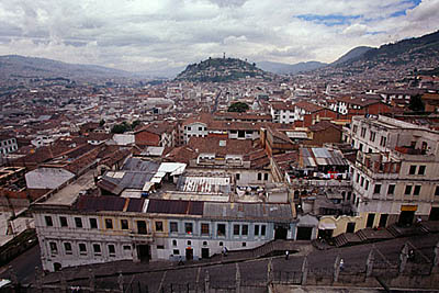
From the Plaza San Francisco, they
were sent up the Panecillo to Pim’s
Restaurant, and they spent
the night on the panecillo.
In the morning (they started the
“morning” with a shot of the Basílica …
The Basílica is a stone/cement
structure 140 m. (+/- 420 ft.) long, and 35 m. (+/- 100 ft.) wide in the main
knave of the church. 15 m. (+/- 45-50 ft.) high in the 24 votive chapels, 74 m
(+/- 250 ft) high in the cross tower; and 115 m. (+/- 380 ft.) high in the two
front towers (including the clock / bell tower). There are seven access doors to
the church… although they only use the main doors, so far as we could tell.

BASÍLICA DEL VOTO NACIONAL
photo credit via
link
The whole church was made of cement and
stone – unfinished both inside and out. They have not and will not finish it
because if they do, they have to pay taxes to Rome, and the purpose of the
church is as a gift from the city to the heart of Christ.
I’ve climbed up
the clock/bell tower as well as the cross tower of that church… when you walk
across to the smaller tower, you walk on the scaffolding set up across the top
of the basílica rooftop
and they showed a view of the
Panecillo that included the large winged statue
(The Virgen de Quito, from the
Iglésia San Francisco, was the model used for this statue, which was constructed
in 1976. It took me a while to get used to seeing it atop the
Panecillo…)
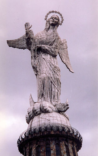
PANECILLO (Little Bread Bun) AS SEEN FROM THE BASILICA
photo
credit via link
They were sent out to the Parque
Nacional Cotopaxi, to the south of the city… to Hacienda
Yanahurco…

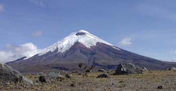
PARQUE NACIONAL
COTOPAXI
photo credit via link
The base of Cotopaxi is quite
desolate – Limpiopungo valley is filled with huge boulders that were spewed by
Cotopaxi when it has erupted in the past.
I have a picture somewhere of my
dad (6’4″ and no small potato) standing in front of one of the boulders — it’s
about 15′ high and 30-40′ wide… Rather impressive when you consider it was
thrown from the mouth of the 19,348 ft. volcano. The largest eruption in
recorded history was in 1877. It had other impressive eruptions in 1904 and
1942, and smaller ones before, between and since those dates. When I lived in
Pifo as a young child, I used to walk along the side of the dirt road and pick
up pieces of obsidian that were thrown from Cotopaxi, and Cotopaxi itself was
still smoking in the distance. We had a large metal bucket full of the “pretty
black glass” we’d find on the road. It’s been picked pretty clean now… I
haven’t found obsidian lying free in a long, long
time.
While they were in Yanahurco, they
were given two choices: Looking through a field for pieces of a military dress
uniform, or trimming wild horse’s hooves and cutting their tails shorter.
Everyone ended up picking the horses.

YANAHURCO
photo credit via
link
Wild horses are so awesome. It
reminded me again of living in Pifo as a little girl — I fell asleep one
afternoon, lying at the bottom of a slide in the playground on the antenna
compound where my father worked. I woke up to this unfamiliar whuffling sound
around me and I laid very still, and opened my eyes to find myself surrounded by
a herd of wild horses, just standing, eating… and sniffing at ME. The whole
situation felt incredibly like a fantasy, but it was very very real, and I was
completely enchanted. Eventually, however, my body had to move. I hoped I
could be slow enough not to frighten them away, but to my dismay, they ran off
in a thunder of hooves, manes and tails…. I still remember the chills I got –
that feeling of being a part of something so very raw and natural – it was like
briefly living inside a storybook…
They took their break at the Mirador
Cotopaxi… just north of the mountain.
I wish they’d shown
more (but I wonder if I’d ever think they showed enough, you know?)
Don’t miss next week’s episode,
They’re starting out in Ecuador,
CBS, 8pm.et/pt
Hopefully they will show more of Ecuador before
they move on to another country. They at the very
least need to get to the Mitad del Mundo (middle of the world)
… it was one of my suggestions. I had hoped, too, that they’d spend their
break night at the Termas de Papallacta. Ah
well.


 Today, I was browsing the internet and came across a quote from a Quichua shaman, talking about Cotacachi (right) which completely lost its ice cap 5 years ago and is no longer perpetually snow covered (as it was, when I was a child)…